Introduction
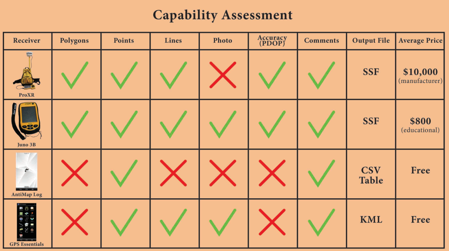
Abstract: Ever since its invention in the early 1970’s, Global Positioning System (GPS) receivers have become a vital tool to better our understanding of the spatial environment around us. The technology was originally intended for military use and national defense, but has grown to become a common instrument for scientific data collection and recreational purposes such as geocaching and exercising. GPS devices are produced with different levels of accuracies and prices in mind, depending on the intended use. This study compares GPS receivers ranging from the industry level to the recreational level, and two GPS smartphone applications in three study areas. Each study area was chosen for their unique challenges they would offer to the accuracies of the units. The four GPS receivers being tested include: Trimble ProXR, Trimble Juno, and smartphone applications AntiMap Log (1.1), and GPS Essentials (4.0.40) (The model of smartphone used is an LG G2).
Abstract: Ever since its invention in the early 1970’s, Global Positioning System (GPS) receivers have become a vital tool to better our understanding of the spatial environment around us. The technology was originally intended for military use and national defense, but has grown to become a common instrument for scientific data collection and recreational purposes such as geocaching and exercising. GPS devices are produced with different levels of accuracies and prices in mind, depending on the intended use. This study compares GPS receivers ranging from the industry level to the recreational level, and two GPS smartphone applications in three study areas. Each study area was chosen for their unique challenges they would offer to the accuracies of the units. The four GPS receivers being tested include: Trimble ProXR, Trimble Juno, and smartphone applications AntiMap Log (1.1), and GPS Essentials (4.0.40) (The model of smartphone used is an LG G2).
GPS Receivers: Two ProXR units are used with one being corrected meaning that it corrects for any atmospheric error and the other being uncorrected. Everything else about these units was the same including all hardware and collection settings. Two Juno 3B units were tested using the same settings on each. This will help test the receivers against each other as well as against the other receivers. AntiMap Log is smartphone application that records points with an attribute table containing latitude, longitude, compass direction (degrees), speed (kph), distance (meters), and time (milliseconds). GPS Essentials collects everything AntiMap Log but only includes comments in the exported attribute table. GPS Essentials also have many more functionalities compared to AntiMap Log.
Study area: The UWEC McPhee Outdoor Track is located on the upper campus of the University of Wisconsin Eau Claire. Tree cover is minimal and the only nearby building is storage for the track. This study area was chosen for the low amount of possible interference the GPS receivers may experience in the hope that all of the receivers will experience similar accuracy.
Methodology: The six GPS receivers were dispersed amongst three data collectors. One person had both Junos, another had one ProXR, and the third had the other ProXR and the smartphone applications. Each collector made four counter-clockwise laps around the track staying along the inside line of the inner most lane. The smartphone apps were ran concurrently on the same smartphone to minimize discrepancies between different collectors GPS Essentials collected a line while AntiMap Log collected points for the path. The data was visualized within ArcMap 10.2.2. The point to line tool was ran for the AntiMap Log path.
Results: All of the receivers collected very similar paths. One of the Junos stopped collecting on the southern turn of the track and began collecting again on the eastern side which is why there is a blue line through the field. Overall the Junos and ProXRs were comparatively the same. The smartphone applications collected mostly accurate paths. The data for the applications begins off of the track but after the first 200 meters they started to become more accurate but still had issues around the north side.

Conclusions:
The ProXRs and Junos had similar paths and were overall the most
accurate for this study area. For surveying purposes either the ProXrs
or Junos would perform equally well however one of the Junos did have
trouble staying connected the satellites. Both of the smartphone
applications performed well if the purpose is for visualizing the route
of a run or other form of activity. It’s also much more convenient to
carry a smartphone rather than a larger GPS unit while exercising.
Carson Park Football Field
Carson Park Football Field
Study
Area: The Carson Park Football Field is located in Carson Park, Eau
Claire, WI. The park is open to the community and is home to numerous
local sports teams. The football field was chosen for the varied tree
cover surrounding it. Past the western end zone is a high amount of tree
cover compared to virtually none on the eastern side. On the north,
south, and east sidelines are stands for spectators.
Methodology: The six GPS receivers were dispersed amongst two data collectors. Each person had one Juno (both had the same settings) and one Pro XR (one of which was uncorrected). These four units were set to collect polygons. The smartphone apps were ran concurrently on the same smartphone to minimize discrepancies between different collectors GPS Essentials collected a line while AntiMap Log collected points for the path. Both collectors walked counter-clockwise around the football field staying walking on the sideline. The data was visualized within ArcMap 10.2.2. The point to line tool was ran for the AntiMap Log path.
Results: Both PRO XR units collected very accurate paths while the Junos and smartphone applications had major issues. One of the Junos stopped collecting data near the 30 yard line on the southern sideline and restarted collecting data by the 30 yard line on the northern sideline. The other Juno struggled to achieve accurate data along the entire path but the smartphone applications were by far the worst at collecting an accurate path. AntiMap Log collected data at a higher rate than GPS Essentials but overall the two paths are very comparable.

Conclusions:
The ProXRs by far collected the most accurate paths with very minor
discrepancies between the corrected and uncorrected units. For
recreational use such as geocaching the smartphone apps are suggested.
GPS Essentials has an on screen map of the data collected while AntiMap
Log only shows the coordinates and other data collected for each point
as it is collecting. If surveying this area the ProXR should be highly
considered compared to the Juno because of the quality of data
collected.
Downtown Eau Claire
Study
Area: Downtown Eau Claire is located at the confluence of the Chippewa
and Eau Claire Rivers in West-Central Wisconsin. The area has a
community park, multiple parking lots and a small business district.
Most buildings in downtown Eau Claire are no more than three stories in
height. This study area proved to be the most challenging for the
receivers.
Methodology:
The six GPS receivers were placed in the back window area of a car as
it was driven through the city. The receivers were driven
counter-clockwise around the area starting and finishing in the
northwest corner of the study area. All of the units (minus AntiMap Log)
were set to record lines for this test. The data was visualized within
ArcMap 10.2.2 and the point to line tool was ran for the AntiMap Log
path.
Results:
The corrected ProXR and one of the Junos failed to collect anything for
this test and the other Juno only collected a minor amount of data. The
smartphone applications had no trouble in collecting the entire route
along with the uncorrected ProXR. The buildings must have had a large
part in interfering with the GPS signals. The standards on the corrected
ProXR did not allow for it to record the deleted signals. The accuracy
of the receivers on the eastern side of the area is much higher compared
to the western side with there being a large amount of continuous
overlap amongst the signals.

No comments:
Post a Comment